
1951 Map of Free Peoples Lake
USGS Topo · Published 1951About this map
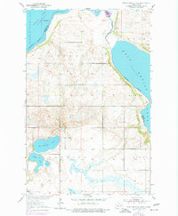
The glacial terrain of Ramsey and Benson Counties is defined by a complex network of wetlands and ephemeral water bodies as documented in 1950. The landscape is dominated by the sprawling reaches of East Devils Lake and South Minnewaukan Lake, which serve as the primary hydrologic landmarks for the surrounding townships. This era of rural development is reflected in the placement of small local institutions, specifically the Free Peoples School and numbered districts like School No 8 and School No 2. These sites, along with localized water features such as Free Peoples Lake and Elbow Lake, illustrate the scattered settlement patterns typical of the North Dakota plains during the mid-20th century. The survey provides clear administrative boundaries for the townships of Odessa, Warwick, Minco, and Loh Nes.
Find a feature on this map
12 named features on this map. Tap any name to fly to it.
Don’t see what you’re looking for? This feature index may not catch every label — zoom into the map to look around manually.
Map Details
Editions of this 1951 Free Peoples Lake Map
2 editions found
Other maps of this area

1928 · Tokio
USGS Topo · 1:62,500

1930 · Hamar
USGS Topo · 1:62,500

1931 · Tokio
USGS Topo · 1:62,500

1931 · Devils Lake
USGS Topo · 1:62,500

1950 · Tokio
USGS Topo · 1:24,000

1950 · Devils Lake
USGS Topo · 1:62,500

1950 · Devils Lake Mountain
USGS Topo · 1:24,000

1951 · Crary
USGS Topo · 1:24,000

1951 · Devils Lake Mountain
USGS Topo · 1:24,000

1951 · Devils Lake
USGS Topo · 1:24,000