1977 Map of Free Union
USGS Topo · Published 1982About this map
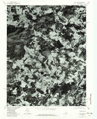
Free Union and its surrounding Piedmont landscape are captured here in 1977, showing a transition between agricultural plateaus and the rising foothills of the Blue Ridge. The settlement patterns follow the winding watercourses of the Lynch River and Moormans River, which converge toward the southeast. This orthophotoquad provides an unvarnished view of land use, where the wooded slopes of Buck Mountain and Piney Mountain contrast with the cleared pasturelands near Crossroads and Boonesville. In the lower corner, the S Fk Rivanna River Reservoir appears as a significant hydrologic feature, fed by the Mechums River. Small rural hamlets like Nortonsville are shown at the junctions of local roads, illustrating the persistent 20th-century rural character of Albemarle County before significant suburban expansion.
Find a feature on this map
14 named features on this map. Tap any name to fly to it.
Don’t see what you’re looking for? This feature index may not catch every label — zoom into the map to look around manually.
Map Details
Editions of this 1977 Free Union Map
This is the sole edition of this map. No revisions or reprints were ever made.
Other maps of this area

1892 · Gordonsville
USGS Topo · 1:125,000

1892 · Harrisonburg
USGS Topo · 1:125,000

1930 · Madison
USGS Topo · 1:48,000

1931 · University
USGS Topo · 1:62,500

1933 · Madison
USGS Topo · 1:62,500

1935 · Charlottesville
USGS Topo · 1:62,500

1935 · University
USGS Topo · 1:62,500

1937 · Elkton
USGS Topo · 1:62,500

1939 · Charlottesville
USGS Topo · 1:62,500

1949 · Charlottesville
USGS Topo · 1:250,000