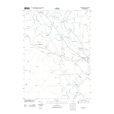
2013 Map of Freehold
USGS Topo · Published 2013About this map
East Durham and Freehold anchor the northern landscape of this Greene County survey, where the winding course of Catskill Cr and Basic Cr define the local drainage patterns. The map documents a cluster of settlements including Sunside, South Durham, and Acra, which sit along the transition from the rolling valley floor to the high peaks of the Catskill Mountains. Significant elevation changes are marked by prominent summits like Blackhead, Black Dome, and Acra Point, while the southeastern corner descends toward the community of Purling along the Shingle Kill. Genealogists and local historians will find value in the precise location of family and community burial grounds, such as Snyder Cem, Taylor Cem, and the Cairo Village Cem. The presence of the Freehold Airport and the Armstrongs Elk Farm indicates a diverse mix of modern recreation, transportation, and agricultural land use in this part of upstate New York.
Find a feature on this map
140 named features on this map. Tap any name to fly to it.
Don’t see what you’re looking for? This feature index may not catch every label — zoom into the map to look around manually.
Map Details
Editions of this 2013 Freehold Map
This is the sole edition of this map. No revisions or reprints were ever made.
Other maps of this area

1892 · Kaaterskill
USGS Topo · 1:62,500

1893 · Kaaterskill
USGS Topo · 1:62,500

1893 · Coxsackie
USGS Topo · 1:62,500

1893 · Durham
USGS Topo · 1:62,500

1894 · Coxsackie
USGS Topo · 1:62,500

1894 · Kaaterskill
USGS Topo · 1:62,500

1894 · Durham
USGS Topo · 1:62,500

1895 · Catskill
USGS Topo · 1:62,500

1899 · Kaaterskill
USGS Topo · 1:62,500

1903 · Kaaterskill
USGS Topo · 1:62,500