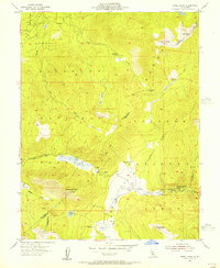
1955 Map of Freel Peak
USGS Topo · Published 1956About this map
Freel Peak dominates this high-altitude landscape of the central Sierra Nevada, marking the rugged divide between the Eldorado National Forest and Toiyabe National Forest. The map documents a critical transition point for travelers and timber interests, centered on the crossing at Luther Pass. While much of the terrain is defined by dramatic peaks like Jobs Sister and Waterhouse Peak, the lower elevations reveal pockets of human activity and seasonal settlement. The West Fork Carson River carves a path through the southeastern corner, where Sorensens and camps such as Dangberg Camp and Kit Carson Campground provided footholds for travelers. Faded industry is noted by a solitary Shaft located west of Tucker Flat, hinting at the mineral prospecting that once peppered these high meadows and ridges.
Find a feature on this map
30 named features on this map. Tap any name to fly to it.
Don’t see what you’re looking for? This feature index may not catch every label — zoom into the map to look around manually.
Map Details
Editions of this 1955 Freel Peak Map
4 editions found
Other maps of this area

1889 · Pyramid Peak
USGS Topo · 1:125,000

1889 · Markleeville
USGS Topo · 1:125,000

1891 · Markleeville
USGS Topo · 1:125,000

1891 · Pyramid Peak
USGS Topo · 1:125,000

1893 · Markleeville
USGS Topo · 1:125,000

1895 · Pyramid Peak
USGS Topo · 1:125,000

1896 · Pyramid Peak
USGS Topo · 1:125,000

1947 · Sacramento
USGS Topo · 1:250,000

1948 · Walker Lake
USGS Topo · 1:250,000

1948 · Sacramento
USGS Topo · 1:250,000