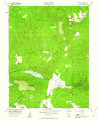
1955 Map of Freel Peak
USGS Topo · Published 1961About this map
Freel Peak and Jobs Sister dominate this high-altitude landscape along the border of El Dorado and Alpine counties. This mid-century survey captures a transition point for backcountry travel, centered on the strategic Luther Pass, where early routes connected the Tahoe basin to the West Fork of the Carson River. The map reveals small outposts like Sorensens and Dangberg Camp along the river valley, which served as important markers for those navigating the eastern Sierra. To the north, the terrain drops toward Fountain Place and the headwaters of Trout Creek. Localized industrial activity is evidenced by a lone Shaft located west of Saxon Creek, while the expansive alpine meadows of Big Meadow and Freel Meadows suggest the area's continued importance for summer grazing within the El Dorado National Forest and Toiyabe National Forest.
Find a feature on this map
33 named features on this map. Tap any name to fly to it.
Don’t see what you’re looking for? This feature index may not catch every label — zoom into the map to look around manually.
Map Details
Editions of this 1955 Freel Peak Map
4 editions found
Other maps of this area

1889 · Pyramid Peak
USGS Topo · 1:125,000

1889 · Markleeville
USGS Topo · 1:125,000

1891 · Markleeville
USGS Topo · 1:125,000

1891 · Pyramid Peak
USGS Topo · 1:125,000

1893 · Markleeville
USGS Topo · 1:125,000

1895 · Pyramid Peak
USGS Topo · 1:125,000

1896 · Pyramid Peak
USGS Topo · 1:125,000

1947 · Sacramento
USGS Topo · 1:250,000

1948 · Walker Lake
USGS Topo · 1:250,000

1948 · Sacramento
USGS Topo · 1:250,000