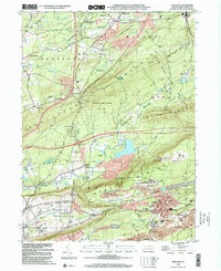
1999 Map of Freeland
USGS Topo · Published 2001About this map
Freeland and its neighboring coal-country settlements occupy the high plateau and ridges of the anthracite region at the turn of the millennium. The landscape is defined by the heavy footprint of industry, notably the extensive strip mines that scar the slopes of Green Mountain and Buck Mountain. These industrial features sit in stark contrast to the protected acreage of State Game Lands No 187, which covers the central Nescopeck Mountain range.
Find a feature on this map
57 named features on this map. Tap any name to fly to it.
Don’t see what you’re looking for? This feature index may not catch every label — zoom into the map to look around manually.
Map Details
Editions of this 1999 Freeland Map
This is the sole edition of this map. No revisions or reprints were ever made.
Other maps of this area

1889 · Hazleton
USGS Topo · 1:62,500

1891 · Wilkesbarre
USGS Topo · 1:62,500

1891 · Hazleton
USGS Topo · 1:62,500

1892 · Mahanoy
USGS Topo · 1:62,500

1893 · Hazleton
USGS Topo · 1:62,500

1893 · Mahanoy
USGS Topo · 1:62,500

1894 · Shickshinny
USGS Topo · 1:62,500

1894 · Wilkesbarre
USGS Topo · 1:62,500

1943 · Scranton
USGS Topo · 1:125,000

1944 · Newark
USGS Topo · 1:250,000