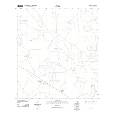
2010 Map of Freer NW
USGS Topo · Published 2010About this map
The Government Wells Oil Field defines the southeastern corner of this South Texas landscape, illustrating the region's long-standing connection to the petroleum industry. Just west of Freer, the terrain is characterized by an extensive network of ephemeral drainages and stock tanks essential for ranching in this arid climate. Water management is a central theme, evidenced by numerous man-made reservoirs like Piedra Tank, Coma Tank, and Rincon Tank, often supported by infrastructure such as the Duval County Ranch Cochina Tank Dam.
Find a feature on this map
23 named features on this map. Tap any name to fly to it.
Don’t see what you’re looking for? This feature index may not catch every label — zoom into the map to look around manually.
Map Details
Editions of this 2010 Freer NW Map
This is the sole edition of this map. No revisions or reprints were ever made.
Other maps of this area

1937 · Loma Alta
USGS Topo · 1:62,500

1953 · Crystal City
USGS Topo · 1:250,000

1955 · Crystal City
USGS Topo · 1:250,000

1956 · Freer
USGS Topo · 1:62,500

1956 · Piedra Creek
USGS Topo · 1:62,500

1956 · Las Mujeres
USGS Topo · 1:62,500

1956 · Laredo
USGS Topo · 1:250,000

1961 · Crystal City
USGS Topo · 1:250,000

1968 · Crystal City
USGS Topo · 1:250,000
1969 · Loma Alta
USGS Topo · 1:24,000