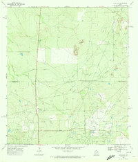
1969 Map of Loma Alta
USGS Topo · Published 1972About this map
The South Texas brush country at the McMullen and Duval County line is defined by a sprawling landscape of energy extraction and ranching as seen in the late 1960s. The Hagist Ranch Oil Field, Seven Sisters Oil Field, and Eagle Hill Oil Field dominate the topography, revealing a complex network of pipelines and service roads linking numerous Oil Wells and the Hagist Ranch Gas Plant. This industrial footprint is overlaid on established grazing lands like the Hagist Ranch and Foster Ranch, illustrating the dual-use nature of the land during the mid-century petroleum boom.
Find a feature on this map
22 named features on this map. Tap any name to fly to it.
Don’t see what you’re looking for? This feature index may not catch every label — zoom into the map to look around manually.
Map Details
Editions of this 1969 Loma Alta Map
2 editions found
Other maps of this area

1920 · Mikeska
USGS Topo · 1:125,000

1937 · Loma Alta
USGS Topo · 1:62,500

1953 · Crystal City
USGS Topo · 1:250,000

1955 · Crystal City
USGS Topo · 1:250,000

1956 · Rosita Ranch
USGS Topo · 1:62,500

1956 · Freer
USGS Topo · 1:62,500

1956 · Laredo
USGS Topo · 1:250,000

1961 · Crystal City
USGS Topo · 1:250,000

1968 · Crystal City
USGS Topo · 1:250,000
1969 · Loma Alta NE
USGS Topo · 1:24,000