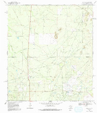
1969 Map of Loma Alta
USGS Topo · Published 1991About this map
The boundary between McMullen Co and Duval Co divides a landscape defined by mid-century energy production and ranching operations. In the late 1960s, the terrain was dominated by the Hagist Ranch Oil Field and the Seven Sisters Oil Field, featuring a dense network of pipelines, oil wells, and gravel pits. The infrastructure of the Hagist Ranch Gas Plant stands as a significant industrial landmark amidst the arid South Texas brush country.
Find a feature on this map
21 named features on this map. Tap any name to fly to it.
Don’t see what you’re looking for? This feature index may not catch every label — zoom into the map to look around manually.
Map Details
Editions of this 1969 Loma Alta Map
2 editions found
Other maps of this area

1920 · Mikeska
USGS Topo · 1:125,000

1937 · Loma Alta
USGS Topo · 1:62,500

1953 · Crystal City
USGS Topo · 1:250,000

1955 · Crystal City
USGS Topo · 1:250,000

1956 · Rosita Ranch
USGS Topo · 1:62,500

1956 · Freer
USGS Topo · 1:62,500

1956 · Laredo
USGS Topo · 1:250,000

1961 · Crystal City
USGS Topo · 1:250,000

1968 · Crystal City
USGS Topo · 1:250,000
1969 · Loma Alta NE
USGS Topo · 1:24,000