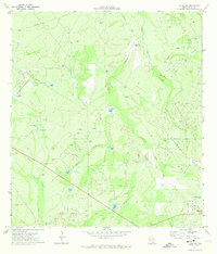
1971 Map of Freer NW
USGS Topo · Published 1974About this map
The Government Wells Oil Field dominates this South Texas landscape in the early 1970s, illustrating the intensive petroleum infrastructure north of Freer. The terrain is defined by a dense network of extraction sites, including dozens of Oil Well locations and a Pumping Sta, interconnected by a series of pipelines. Water management for ranching or industry is evident through numerous named stock tanks, such as Piedra Tank, Cochina Tank, and Rincon Tank, which punctuate the drainage basins of Ygnacio Creek and Government Creek. This geography reveals a specialized economy where natural resources and water security dictated the placement of every road and structure. The proximity of Soledad Creek and Charamusca Creek highlights the intermittent drainage patterns common to Duval County, while the Sewage Disposal Pond near the town site marks the early modern utility footprint of the era.
Find a feature on this map
24 named features on this map. Tap any name to fly to it.
Don’t see what you’re looking for? This feature index may not catch every label — zoom into the map to look around manually.
Map Details
Editions of this 1971 Freer NW Map
This is the sole edition of this map. No revisions or reprints were ever made.
Other maps of this area

1937 · Loma Alta
USGS Topo · 1:62,500

1953 · Crystal City
USGS Topo · 1:250,000

1955 · Crystal City
USGS Topo · 1:250,000

1956 · Freer
USGS Topo · 1:62,500

1956 · Piedra Creek
USGS Topo · 1:62,500

1956 · Las Mujeres
USGS Topo · 1:62,500

1956 · Laredo
USGS Topo · 1:250,000

1961 · Crystal City
USGS Topo · 1:250,000

1968 · Crystal City
USGS Topo · 1:250,000
1969 · Loma Alta
USGS Topo · 1:24,000