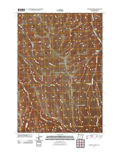
2011 Map of Freezeout Ridge
USGS Topo · Published 2011About this map
Freezeout Ridge dominates the southern landscape of this Oregon-Morrow County border region, where a complex network of canyons and drainage forks defines the high country. The terrain is deeply incised by the Kilkenny Fork and Hinton Creek, which converge as they flow through the central portion of the map. In the northeast, Little Butter Creek carves a path alongside Sawmill Canyon and Howard Canyon, indicating a history of timber or water resource utilization.
Find a feature on this map
17 named features on this map. Tap any name to fly to it.
Don’t see what you’re looking for? This feature index may not catch every label — zoom into the map to look around manually.
Map Details
Editions of this 2011 Freezeout Ridge Map
This is the sole edition of this map. No revisions or reprints were ever made.
Other maps of this area

1953 · Pendleton
USGS Topo · 1:250,000

1956 · Pendleton
USGS Topo · 1:250,000

1967 · Freezeout Ridge
USGS Topo · 1:24,000

1968 · Hoodlum Canyon
USGS Topo · 1:24,000

1968 · Lena
USGS Topo · 1:24,000

1968 · Gleason Butte
USGS Topo · 1:24,000
1968 · Franklin Hill
USGS Topo · 1:24,000

1968 · Skinners Fork
USGS Topo · 1:24,000

1969 · Summerfield Ridge
USGS Topo · 1:24,000

1969 · Arbuckle Mtn
USGS Topo · 1:24,000