
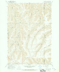
1967 Map of Freezeout Ridge
USGS Topo · Published 1971About this map
Freezeout Ridge dominates this 1960s landscape in Morrow County, where a complex system of drainages carves through the high terrain. The map documents the rural infrastructure of the era, including the Heppner City Well and the small settlement of Luckman situated near Howard Canyon. Steep-walled corridors like Big Sourdough Canyon and Little Sourdough Canyon define the eastern portion of the sheet, while Hinton Creek and Willow Creek flow through the western valleys. Numerous springs are noted throughout the quadrangle, serving as vital water sources in this upland environment. The presence of a Jeep Trail and other primitive paths suggests a landscape managed for ranching or resource access, connecting remote points like the Freeze No 3 landmark to the more established routes along Little Butter Creek.
Find a feature on this map
18 named features on this map. Tap any name to fly to it.
Don’t see what you’re looking for? This feature index may not catch every label — zoom into the map to look around manually.
Map Details
Editions of this 1967 Freezeout Ridge Map
This is the sole edition of this map. No revisions or reprints were ever made.
Other maps of this area

1953 · Pendleton
USGS Topo · 1:250,000

1956 · Pendleton
USGS Topo · 1:250,000

1968 · Hoodlum Canyon
USGS Topo · 1:24,000

1968 · Lena
USGS Topo · 1:24,000

1968 · Gleason Butte
USGS Topo · 1:24,000
1968 · Franklin Hill
USGS Topo · 1:24,000

1968 · Skinners Fork
USGS Topo · 1:24,000

1969 · Summerfield Ridge
USGS Topo · 1:24,000

1969 · Arbuckle Mtn
USGS Topo · 1:24,000
1969 · Matlock Prairie
USGS Topo · 1:24,000