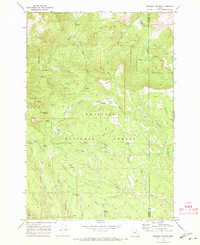
1969 Map of Matlock Prairie
USGS Topo · Published 1973About this map
The Umatilla National Forest defines this high-elevation landscape along the border of Morrow and Umatilla counties. In the late 1960s, this area was characterized by a network of seasonal grazing lands and water sources, notably Matlock Prairie and several others like Balsinger and Kenny Prairie. The map captures a moment of active forest management and livestock ranching, evidenced by landmarks such as the Ellis Forest Service Station and the Fivemile Cow Camp.
Find a feature on this map
44 named features on this map. Tap any name to fly to it.
Don’t see what you’re looking for? This feature index may not catch every label — zoom into the map to look around manually.
Map Details
Editions of this 1969 Matlock Prairie Map
2 editions found
Other maps of this area

1953 · Pendleton
USGS Topo · 1:250,000

1956 · Pendleton
USGS Topo · 1:250,000

1967 · Freezeout Ridge
USGS Topo · 1:24,000

1968 · Hoodlum Canyon
USGS Topo · 1:24,000

1968 · Gurdane
USGS Topo · 1:24,000

1969 · Lake Penland
USGS Topo · 1:24,000

1969 · Sugarbowl Creek
USGS Topo · 1:24,000

1969 · Deerhorn Creek
USGS Topo · 1:24,000

1969 · Thompson Flat
USGS Topo · 1:24,000

1969 · Arbuckle Mtn
USGS Topo · 1:24,000