
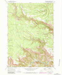
1969 Map of Deerhorn Creek
USGS Topo · Published 1973About this map
The North Fork John Day River winds through the southern edge of this landscape, carving a deep corridor beneath the heights of Buckaroo Flat and Deerhorn Ridge. This territory within the Umatilla National Forest is defined by a complex drainage network, where Deerhorn Creek and Jericho Creek descend through steep canyons toward the river. Human presence is sparse, marked primarily by utilitarian locations and remote outposts.
Find a feature on this map
28 named features on this map. Tap any name to fly to it.
Don’t see what you’re looking for? This feature index may not catch every label — zoom into the map to look around manually.
Map Details
Editions of this 1969 Deerhorn Creek Map
2 editions found
Other maps of this area

1950 · Ritter
USGS Topo · 1:62,500

1951 · Dale
USGS Topo · 1:62,500

1952 · Ritter
USGS Topo · 1:62,500

1953 · Pendleton
USGS Topo · 1:250,000

1955 · Canyon City
USGS Topo · 1:250,000

1956 · Pendleton
USGS Topo · 1:250,000

1959 · Canyon City
USGS Topo · 1:250,000

1967 · Bridge Creek
USGS Topo · 1:24,000

1967 · Ukiah
USGS Topo · 1:24,000

1969 · Sugarbowl Creek
USGS Topo · 1:24,000