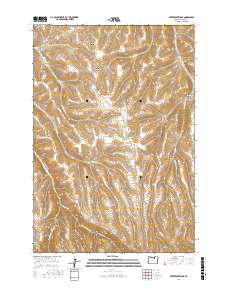
2017 Map of Freezeout Ridge
USGS Topo · Published 2017About this map
Freezeout Ridge dominates this section of the Oregon-Morrow County line, where high-altitude drainages carve deep canyons into the plateau. The landscape is defined by its complex hydrography, specifically the headwaters of the Kilkenny Fork and Hinton Cr, which navigate between prominent landforms like Jones Canyon and Luckman Canyon. Human imprint on the terrain is sparse, primary represented by remote ranching infrastructure. Blake Ranch Rd and Willow Creek Rd serve as the principal transit arteries through these uplands, following the natural contours of the ridges and valleys. The presence of Sawmill Canyon and Trail Canyon suggests a history of local resource extraction and movement through these high-desert corridors, while the names of Big Sourdough Canyon and Little Sourdough Canyon provide a glimpse into the regional vernacular and pioneer-era place naming.
Find a feature on this map
21 named features on this map. Tap any name to fly to it.
Don’t see what you’re looking for? This feature index may not catch every label — zoom into the map to look around manually.
Map Details
Editions of this 2017 Freezeout Ridge Map
This is the sole edition of this map. No revisions or reprints were ever made.
Other maps of this area

1953 · Pendleton
USGS Topo · 1:250,000

1956 · Pendleton
USGS Topo · 1:250,000

1967 · Freezeout Ridge
USGS Topo · 1:24,000

1968 · Hoodlum Canyon
USGS Topo · 1:24,000

1968 · Lena
USGS Topo · 1:24,000

1968 · Gleason Butte
USGS Topo · 1:24,000
1968 · Franklin Hill
USGS Topo · 1:24,000

1968 · Skinners Fork
USGS Topo · 1:24,000

1969 · Summerfield Ridge
USGS Topo · 1:24,000

1969 · Arbuckle Mtn
USGS Topo · 1:24,000