
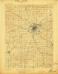
1893 Map of Fremont
USGS Topo · Published 1960About this map
The Platte River and the Elkhorn River converge in this late nineteenth-century landscape, carving a broad valley through eastern Nebraska. The map illustrates a dense network of early western railroads, including the Union Pacific R.R. and the Fremont Elkhorn & Mo. Val. R.R., which dictated the placement of emerging rail towns like Arlington, Valley, and Waterloo. Near the Missouri River, Fort Calhoun and Benson represent the edge of growing settlement centers, while the interior is marked by smaller railroad stops and junctions such as Chalco and Papillion. The terrain is characterized by the complex drainage systems of Big Papillion Creek and Bell Creek, highlighting the importance of water access for agriculture and transportation before the turn of the century. This survey, supervised by Jno. H. Renshawe, provides an essential record of the original county boundaries and town placements that defined the Omaha-Lincoln corridor.
Find a feature on this map
89 named features on this map. Tap any name to fly to it.
Don’t see what you’re looking for? This feature index may not catch every label — zoom into the map to look around manually.
Map Details
Editions of this 1893 Fremont Map
This is the sole edition of this map. No revisions or reprints were ever made.
Other maps of this area

1893 · Omaha
USGS Topo · 1:62,500

1896 · Fremont
USGS Topo · 1:125,000
1897 · Lincoln
USGS Topo · 1:125,000

1899 · Wahoo
USGS Topo · 1:125,000

1903 · Weeping Water
USGS Topo · 1:125,000

1929 · Weeping Water
USGS Topo · 1:125,000
1935 · Nehawka
USGS Topo · 1:48,000
1940 · Nehawka
USGS Topo · 1:62,500

1954 · Omaha
USGS Topo · 1:250,000

1955 · Fremont
USGS Topo · 1:250,000