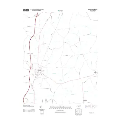
2013 Map of Fremont
USGS Topo · Published 2013About this map
Fremont stands as the central hub of this eastern North Carolina landscape, where the grid of the town core meets a web of country roads and low-lying wetlands. The geography is defined by a series of drainage systems, including the extensive Aycock Swamp and Nahunta Swamp, which dictate the placement of local thoroughfares and farm boundaries. To the east, the smaller settlement of Eureka sits near the edge of the swampy terrain, while Edmundson Crossroads marks a key junction to the south. This coastal plain environment is characterized by its agricultural legacy, seen in the numerous family-named routes such as Arthur Davis Rd and Buck Newsome Rd. Significant water features like West Lake and the meandering Mill Run provide localized landmarks within the broader reach of the Great Swamp, illustrating the persistent influence of the natural hydrology on regional development.
Find a feature on this map
93 named features on this map. Tap any name to fly to it.
Don’t see what you’re looking for? This feature index may not catch every label — zoom into the map to look around manually.
Map Details
Editions of this 2013 Fremont Map
This is the sole edition of this map. No revisions or reprints were ever made.
Other maps of this area

1902 · Kenly
USGS Topo · 1:62,500

1903 · Kenly
USGS Topo · 1:62,500

1904 · Wilson
USGS Topo · 1:62,500

1953 · Rocky Mount
USGS Topo · 1:250,000

1953 · Raleigh
USGS Topo · 1:250,000

1954 · Rocky Mount
USGS Topo · 1:250,000

1954 · Raleigh
USGS Topo · 1:250,000

1957 · Goldsboro
USGS Topo · 1:62,500

1974 · Northwest Goldsboro
USGS Topo · 1:24,000
1978 · Lucama
USGS Topo · 1:24,000