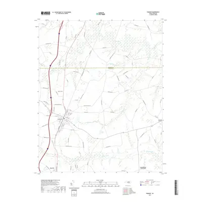
2019 Map of Fremont
USGS Topo · Published 2019About this map
Fremont sits as a central hub on this 2019 survey of the Coastal Plain, where the municipal grid is neatly defined by streets like E Carolina St and S Wilson St. The town's historical geography is anchored by the Elmwood Cem near its eastern edge, providing a focal point for genealogical research. This landscape is defined by its complex drainage network, where the sprawling Nahunta Swamp and Aycock Swamp dominate the low-lying terrain between the small communities of Eureka, Pikeville, and Edmundson Crossroads. The transition between the Wilson and Wayne County border is marked by a shift into the heavily watered basins of Great Swamp and Turner Swamp. The density of named family roads and agricultural pathways across these swampy basins reflects a long-established pattern of rural land use and timber extraction.
Find a feature on this map
80 named features on this map. Tap any name to fly to it.
Don’t see what you’re looking for? This feature index may not catch every label — zoom into the map to look around manually.
Map Details
Editions of this 2019 Fremont Map
This is the sole edition of this map. No revisions or reprints were ever made.
Other maps of this area

1902 · Kenly
USGS Topo · 1:62,500

1903 · Kenly
USGS Topo · 1:62,500

1904 · Wilson
USGS Topo · 1:62,500

1953 · Rocky Mount
USGS Topo · 1:250,000

1953 · Raleigh
USGS Topo · 1:250,000

1954 · Rocky Mount
USGS Topo · 1:250,000

1954 · Raleigh
USGS Topo · 1:250,000

1957 · Goldsboro
USGS Topo · 1:62,500

1974 · Northwest Goldsboro
USGS Topo · 1:24,000
1978 · Lucama
USGS Topo · 1:24,000