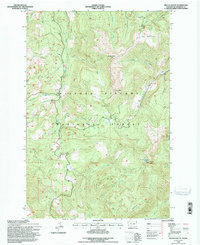
1994 Map of French Butte
USGS Topo · Published 1996About this map
French Butte and the surrounding high country of the Gifford Pinchot National Forest define this 1994 topographic landscape in Skamania County. The map details a complex network of forest roads and drainages established during the late twentieth century, showing the transition from old logging ways to recreational use. Distinctive peaks like Pinto Rock and The Loaf rise above numerous watercourses, including Iron Creek, Ferrous Creek, and Twelvemile Creek. This map reveals the specific geographic arrangement of local landmarks such as Pole Patch and Snyder Pasture, which are significant to the region's land use history. Notable transitions in elevation are centered around Elk Pass, where trails and primitive roads intersect near the headwaters of Clear Creek and Hungry Creek. To the east, Badger Peak stands over Badger Lake, providing a clear record of the area's wilderness character before more modern developments.
Find a feature on this map
30 named features on this map. Tap any name to fly to it.
Don’t see what you’re looking for? This feature index may not catch every label — zoom into the map to look around manually.
Map Details
Editions of this 1994 French Butte Map
This is the sole edition of this map. No revisions or reprints were ever made.
Other maps of this area

1919 · Mount St Helens
USGS Topo · 1:125,000

1926 · Steamboat Mtn
USGS Topo · 1:125,000

1931 · Steamboat Mtn
USGS Topo · 1:125,000

1950 · Yakima
USGS Topo · 1:250,000

1953 · Hoquiam
USGS Topo · 1:250,000

1957 · Hoquiam
USGS Topo · 1:250,000

1957 · Spirit Lake
USGS Topo · 1:62,500

1958 · Mt St. Helens
USGS Topo · 1:62,500

1958 · Yakima
USGS Topo · 1:250,000

1958 · Hoquiam
USGS Topo · 1:250,000