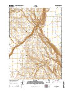
2014 Map of Frenchglen
USGS Topo · Published 2014About this map
Frenchglen sits at the foot of the western slope of the Steens Mountain, serving as a vital hub in this high-desert basin. This 2014 survey details the complex water management system essential to the region, including the Donner und Blitzen River and the extensive Warm Springs Canal. The landscape is defined by its transition from the steep elevation of Jackass Mtn and P Hill down to the broad expanse of the Catlow Valley. Water security in this arid environment is evidenced by numerous named improvements such as Griffith Spring Reservoir, Kundert Reservoir, and Solomon Canyon Reservoir. Long-established ranching routes and modern access points are noted, including the Steens Mountain Back Country Bywy and the Barret Springs Footpath, which traverse the varied terrain of Waterhole Canyon and the La Voy Tables.
Find a feature on this map
37 named features on this map. Tap any name to fly to it.
Don’t see what you’re looking for? This feature index may not catch every label — zoom into the map to look around manually.
Map Details
Editions of this 2014 Frenchglen Map
This is the sole edition of this map. No revisions or reprints were ever made.
Other maps of this area

1955 · Adel
USGS Topo · 1:250,000

1957 · Adel
USGS Topo · 1:250,000

1958 · Adel
USGS Topo · 1:250,000

1962 · Adel
USGS Topo · 1:250,000
1967 · Krumbo Reservoir
USGS Topo · 1:24,000
1967 · Roaring Springs
USGS Topo · 1:24,000
1967 · Frenchglen
USGS Topo · 1:24,000
1967 · Irish Lake
USGS Topo · 1:24,000
1967 · Page Springs
USGS Topo · 1:24,000
1968 · Tombstone Canyon
USGS Topo · 1:24,000