
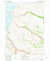
1967 Map of Page Springs
USGS Topo · Published 1972About this map
The Malheur National Wildlife Refuge dominates the western portion of this 1960s survey, where the Blitzen Valley meets the rising slopes of Steens Mountain. The hydrology of this high-desert environment is well-documented, showing the path of the Donner und Blitzen River and the infrastructure used to manage it, including the Page Dam and multiple Gaging Stations. Evidence of ranching and land use is present through the identification of Corrals and various named water sources such as Knox Spring and Frazier Spring. The terrain is defined by deep drainages like Mud Creek and Bridge Creek that carve into the volcanic plateau. This record is particularly valuable for tracing the development of recreation in the area, specifically around the Page Springs Campground, and the established Steens Mountain Road used to navigate this complex topography.
Find a feature on this map
23 named features on this map. Tap any name to fly to it.
Don’t see what you’re looking for? This feature index may not catch every label — zoom into the map to look around manually.
Map Details
Editions of this 1967 Page Springs Map
2 editions found
Other maps of this area

1955 · Adel
USGS Topo · 1:250,000

1957 · Adel
USGS Topo · 1:250,000

1958 · Adel
USGS Topo · 1:250,000

1962 · Adel
USGS Topo · 1:250,000

1967 · Krumbo Reservoir
USGS Topo · 1:24,000

1967 · Roaring Springs
USGS Topo · 1:24,000

1967 · Frenchglen
USGS Topo · 1:24,000
1967 · Irish Lake
USGS Topo · 1:24,000

1968 · Tombstone Canyon
USGS Topo · 1:24,000

1968 · Fish Lake
USGS Topo · 1:24,000