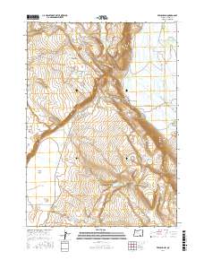
2017 Map of Frenchglen
USGS Topo · Published 2017About this map
Frenchglen sits at the edge of the expansive Blitzen Valley in this recent survey, serving as a gateway to the high desert landscapes of southeastern Oregon. The map illustrates a complex water management system vital for ranching and agriculture in this arid region, featuring the Donner und Blitzen River alongside man-made improvements like the Warm Springs Canal and Bridge Cr Canal. The terrain is defined by dramatic elevation shifts, from the lowlands of the Catlow Valley to the heights of Jackass Mtn and the unique plateau formations of La Voy Tables. Researchers can trace historical water rights and land use through named waterholes and reservoirs such as Broadgate Waterhole, Solomon Canyon Reservoir, and Kundert Reservoir, which highlight the importance of every spring and catchment in the high desert.
Find a feature on this map
30 named features on this map. Tap any name to fly to it.
Don’t see what you’re looking for? This feature index may not catch every label — zoom into the map to look around manually.
Map Details
Editions of this 2017 Frenchglen Map
This is the sole edition of this map. No revisions or reprints were ever made.
Other maps of this area

1955 · Adel
USGS Topo · 1:250,000

1957 · Adel
USGS Topo · 1:250,000

1958 · Adel
USGS Topo · 1:250,000

1962 · Adel
USGS Topo · 1:250,000

1967 · Krumbo Reservoir
USGS Topo · 1:24,000

1967 · Roaring Springs
USGS Topo · 1:24,000

1967 · Frenchglen
USGS Topo · 1:24,000
1967 · Irish Lake
USGS Topo · 1:24,000

1967 · Page Springs
USGS Topo · 1:24,000

1968 · Tombstone Canyon
USGS Topo · 1:24,000