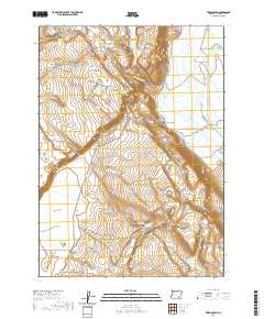
2020 Map of Frenchglen
USGS Topo · Published 2020About this map
Frenchglen sits at the gateway to the high desert, where the lush bottomlands of the Blitzen Valley meet the rising slopes of the Steens Mountain foothills. This area is defined by a complex hydraulic landscape, where the Donner und Blitzen River is diverted into the Warm Springs Canal and Bridge Creek Canal to manage water through the basin. High ground is marked by prominent landmarks such as Jackass Mtn and P Hill, while the western portion of the map descends into the wide expanse of the Catlow Valley. The mapping of features like the Burns Springs Footpath and Bridge Creek Trail indicates a landscape that, while sparsely populated, remains vital for recreation and range management. Numerous water resources, including Griffith Spring Reservoir and Boardgate Waterhole, underscore the importance of water access in this arid Oregon interior.
Find a feature on this map
32 named features on this map. Tap any name to fly to it.
Don’t see what you’re looking for? This feature index may not catch every label — zoom into the map to look around manually.
Map Details
Editions of this 2020 Frenchglen Map
This is the sole edition of this map. No revisions or reprints were ever made.
Other maps of this area

1955 · Adel
USGS Topo · 1:250,000

1957 · Adel
USGS Topo · 1:250,000

1958 · Adel
USGS Topo · 1:250,000

1962 · Adel
USGS Topo · 1:250,000

1967 · Krumbo Reservoir
USGS Topo · 1:24,000

1967 · Roaring Springs
USGS Topo · 1:24,000

1967 · Frenchglen
USGS Topo · 1:24,000
1967 · Irish Lake
USGS Topo · 1:24,000

1967 · Page Springs
USGS Topo · 1:24,000

1968 · Tombstone Canyon
USGS Topo · 1:24,000