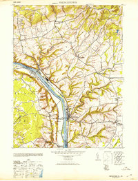
1953 Map of Frenchtown
USGS Topo · Published 1953About this map
The Delaware River serves as the central artery of this region, separating the river towns of Frenchtown and Milford in New Jersey from Upper Black Eddy and Erwinna in Pennsylvania. This mid-century landscape reflects a well-established network of rural schools and civic institutions, including the Frenchtown High School and the Lodge Hall in Baptistown. The steep terrain of Musconetcong Mountain and Riegel Ridge to the north dictates the winding path of local creeks like the Nishisakawick and Lockatong Creek.
Find a feature on this map
48 named features on this map. Tap any name to fly to it.
Don’t see what you’re looking for? This feature index may not catch every label — zoom into the map to look around manually.
Map Details
Editions of this 1953 Frenchtown Map
This is the sole edition of this map. No revisions or reprints were ever made.
Other maps of this area

1890 · Easton
USGS Topo · 1:62,500

1890 · High Bridge
USGS Topo · 1:62,500

1890 · Lambertville
USGS Topo · 1:62,500

1890 · Doylestown
USGS Topo · 1:62,500

1891 · Easton
USGS Topo · 1:62,500

1891 · Lambertville
USGS Topo · 1:62,500

1891 · Doylestown
USGS Topo · 1:62,500

1894 · Lambertville
USGS Topo · 1:62,500

1898 · High Bridge
USGS Topo · 1:62,500

1900 · Raritan
USGS Topo · 1:125,000