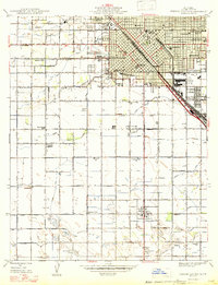
1947 Map of Fresno South
USGS Topo · Published 1947About this map
The agricultural and urban landscape of Fresno emerges in this 1947 edition, reflecting a period of post-war growth and established irrigation networks. The city's southern expansion is anchored by the Fresno Chandler Municipal Airport and institutional landmarks like the Fresno County General Hospital and County Court House. Beyond the urban grid, the Central Valley's reliance on water is evident through a complex web of canals and ditches, including the Southern Pacific Canal, Fresno Canal, and Malaga Canal.
Find a feature on this map
66 named features on this map. Tap any name to fly to it.
Don’t see what you’re looking for? This feature index may not catch every label — zoom into the map to look around manually.
Map Details
Editions of this 1947 Fresno South Map
This is the sole edition of this map. No revisions or reprints were ever made.
Other maps of this area

1921 · Bullard
USGS Topo · 1:31,680

1923 · Kearney Park
USGS Topo · 1:31,680

1923 · Malaga
USGS Topo · 1:31,680

1923 · Herndon
USGS Topo · 1:31,680

1923 · Fresno
USGS Topo · 1:31,680

1923 · Clovis
USGS Topo · 1:31,680

1923 · Bullard
USGS Topo · 1:31,680

1924 · Conejo
USGS Topo · 1:31,680

1925 · Raisin
USGS Topo · 1:31,680

1925 · Caruthers
USGS Topo · 1:31,680