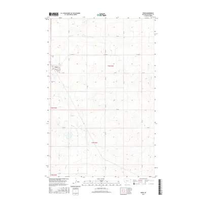
2017 Map of Froid
USGS Topo · Published 2017About this map
Froid serves as the primary hub in this corner of Roosevelt County, Montana, situated at the intersection of Hwy 425 N and several local routes like E N Froid Rd. The town's grid is clearly defined by local streets such as 2nd Ave N, 3rd Ave S, and 6th Ave S. For genealogists, the map identifies two significant burial grounds in the immediate vicinity: Kville Cem to the northwest and South Froid Cem to the southwest, both tucked near the drainage of Sheep Cr. The landscape is dominated by the gentle relief of the Northern Plains, defined by ephemeral waterways like Lost Cr and a dense network of sectional roads such as RD 1020 and RD 1018 that mark the agricultural layout of the region.
Find a feature on this map
25 named features on this map. Tap any name to fly to it.
Don’t see what you’re looking for? This feature index may not catch every label — zoom into the map to look around manually.
Map Details
Editions of this 2017 Froid Map
This is the sole edition of this map. No revisions or reprints were ever made.
Other maps of this area

1914 · Homestead
USGS Topo · 1:62,500

1947 · Capeneys Lake
USGS Topo · 1:24,000

1947 · Homestead
USGS Topo · 1:24,000

1948 · Homestead
USGS Topo · 1:24,000

1948 · Capeneys Lake
USGS Topo · 1:24,000

1948 · Medicine Lake
USGS Topo · 1:24,000
1949 · Medicine Lake
USGS Topo · 1:24,000

1949 · Johnson Lake
USGS Topo · 1:24,000
1950 · Johnson Lake
USGS Topo · 1:24,000

1954 · Wolf Point
USGS Topo · 1:250,000