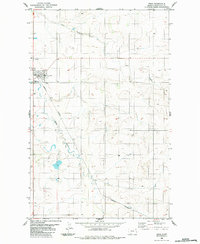
1983 Map of Froid
USGS Topo · Published 1984About this map
Froid serves as the primary hub of this Roosevelt County landscape, where the Burlington Northern railroad cuts a diagonal path through the prairie. The town’s compact grid includes civic landmarks like the Athletic Field, Substa, and a Sewage Disposal Pond at its southern edge. The surrounding terrain is defined by the winding course of Lost Creek to the north and Sheep Creek to the west, with the latter feeding into a series of small, scattered ponds and wetlands.
Find a feature on this map
12 named features on this map. Tap any name to fly to it.
Don’t see what you’re looking for? This feature index may not catch every label — zoom into the map to look around manually.
Map Details
Editions of this 1983 Froid Map
This is the sole edition of this map. No revisions or reprints were ever made.
Other maps of this area

1914 · Homestead
USGS Topo · 1:62,500

1947 · Capeneys Lake
USGS Topo · 1:24,000

1947 · Homestead
USGS Topo · 1:24,000

1948 · Homestead
USGS Topo · 1:24,000

1948 · Capeneys Lake
USGS Topo · 1:24,000

1948 · Medicine Lake
USGS Topo · 1:24,000
1949 · Medicine Lake
USGS Topo · 1:24,000

1949 · Johnson Lake
USGS Topo · 1:24,000
1950 · Johnson Lake
USGS Topo · 1:24,000

1954 · Wolf Point
USGS Topo · 1:250,000