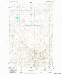
1983 Map of Froid SE
USGS Topo · Published 1984About this map
Devils Kitchen anchors the southeastern reaches of this Roosevelt County landscape, where the high plains of northeastern Montana are carved by seasonal watercourses. The drainage patterns of West Shotgun Creek and East Shotgun Creek define the southern terrain, while Duck Lake and Lost Creek mark the northern and western sections. This 1970s-era topography reveals a land primarily organized by the Public Land Survey System, evidenced by the prominent section lines and the boundary between Township 30 North and Township 29 North.
Find a feature on this map
11 named features on this map. Tap any name to fly to it.
Don’t see what you’re looking for? This feature index may not catch every label — zoom into the map to look around manually.
Map Details
Editions of this 1983 Froid SE Map
This is the sole edition of this map. No revisions or reprints were ever made.
Other maps of this area

1947 · Capeneys Lake
USGS Topo · 1:24,000

1948 · Capeneys Lake
USGS Topo · 1:24,000

1948 · Sunnyhill School
USGS Topo · 1:24,000

1948 · Medicine Lake
USGS Topo · 1:24,000

1949 · Sunnyhill School
USGS Topo · 1:24,000
1949 · Medicine Lake
USGS Topo · 1:24,000

1954 · Wolf Point
USGS Topo · 1:250,000

1958 · Wolf Point
USGS Topo · 1:250,000

1982 · Culbertson
USGS Topo · 1:100,000
1983 · Bainville
USGS Topo · 1:24,000