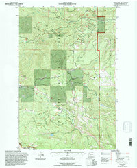
1992 Map of Frost Mtn
USGS Topo · Published 1996About this map
Wenatchee National Forest dominates this topographic study of the Kittitas region, centered on the high-elevation Frost Mtn 6740 Lookout. The landscape is defined by the complex drainage systems of the North Fork and South Fork Taneum Creek to the north, and the Manastash Creek system to the south. Recreational and resource management patterns are visible through the network of forest roads and trails, including the Taneum Ridge Trail and Quartz Mountain Road. High-country meadows such as Keenan Meadows, Buck Meadows, and South Fork Meadow punctuate the timbered ridges. Along the eastern boundary, the transition into the L T Murray State Wildlife Area is marked, while alpine water bodies like Manastash Lake and Lost Lake occupy the southern basins, providing a detailed look at the hydrology of the eastern Cascades.
Find a feature on this map
34 named features on this map. Tap any name to fly to it.
Don’t see what you’re looking for? This feature index may not catch every label — zoom into the map to look around manually.
Map Details
Editions of this 1992 Frost Mtn Map
This is the sole edition of this map. No revisions or reprints were ever made.
Other maps of this area

1897 · Mount Stuart
USGS Topo · 1:125,000

1899 · Ellensburg
USGS Topo · 1:125,000

1901 · Ellensburg
USGS Topo · 1:125,000

1901 · Snoqualmie Pass
USGS Topo · 1:125,000

1902 · Mount Aix
USGS Topo · 1:125,000

1902 · Mount Stuart
USGS Topo · 1:125,000

1903 · Snoqualmie
USGS Topo · 1:125,000

1904 · Mt Aix
USGS Topo · 1:125,000

1950 · Yakima
USGS Topo · 1:250,000

1957 · Wenatchee
USGS Topo · 1:250,000