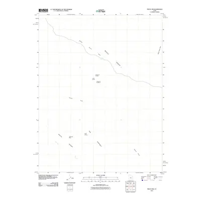
2010 Map of Fruita NW
USGS Topo · Published 2010About this map
Middle Desert topography dominates this section of Emery County, where the erosion of the Hartnet region has carved a distinct landscape of spires and monoliths. Prominent geologic features including the Temple of the Sun and the Temple of the Moon stand as isolated landmarks near the Lower Group, reflecting the area's characteristic cathedral-like formations. Drainage patterns are defined by the winding course of the Middle Desert Wash, which is fed by smaller sources such as Campers Spring. Further south, the terrain shifts toward the South Desert, overseen by the high vantage point of the South Desert Overlook and the massive form of Jailhouse Rock. The map illustrates a remote environment where water is a scarce and vital architect, evidenced by the paths of Hartnet Draw and Deep Creek as they cut through the arid soil.
Find a feature on this map
12 named features on this map. Tap any name to fly to it.
Don’t see what you’re looking for? This feature index may not catch every label — zoom into the map to look around manually.
Map Details
Editions of this 2010 Fruita NW Map
This is the sole edition of this map. No revisions or reprints were ever made.
Other maps of this area

1885 · Fish Lake
USGS Topo · 1:250,000

1896 · Fish Lake
USGS Topo · 1:250,000

1952 · Notom 2 SE
USGS Topo · 1:24,000

1952 · Notom 2 NE
USGS Topo · 1:24,000

1952 · Notom 1 SW
USGS Topo · 1:24,000

1952 · Torrey
USGS Topo · 1:62,500

1953 · Emery 4 SE
USGS Topo · 1:24,000

1954 · Notom 1 NE
USGS Topo · 1:24,000

1954 · Fruita
USGS Topo · 1:62,500
1954 · Notom 1 SE
USGS Topo · 1:24,000