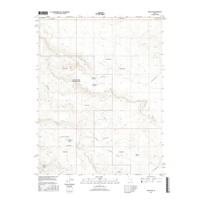
2017 Map of Fruita NW
USGS Topo · Published 2017About this map
Capitol Reef National Park dominates this Utah landscape, revealing a high-desert environment defined by striking geological monoliths and arid drainage systems. The map highlights the iconic Temple of the Sun and Temple of the Moon rising from the Middle Desert, alongside the massive Jailhouse Rock situated near the South Desert. This area serves as a primary study of the Water Pocket Fold, a significant monocline that dictates the region's topography. Navigational routes like Hartnet Road and Jail House Rd trace the accessible paths through these remote canyons and flats. Critical water sources, essential for survival in this environment, are clearly marked at Campers Spring and Rockwater Spring, while seasonal drainage is illustrated by the complex networks of Deep Cr and the Hartnet Draw.
Find a feature on this map
27 named features on this map. Tap any name to fly to it.
Don’t see what you’re looking for? This feature index may not catch every label — zoom into the map to look around manually.
Map Details
Editions of this 2017 Fruita NW Map
This is the sole edition of this map. No revisions or reprints were ever made.
Other maps of this area

1885 · Fish Lake
USGS Topo · 1:250,000

1896 · Fish Lake
USGS Topo · 1:250,000

1952 · Notom 2 SE
USGS Topo · 1:24,000

1952 · Notom 2 NE
USGS Topo · 1:24,000

1952 · Notom 1 SW
USGS Topo · 1:24,000

1952 · Torrey
USGS Topo · 1:62,500

1953 · Emery 4 SE
USGS Topo · 1:24,000

1954 · Notom 1 NE
USGS Topo · 1:24,000

1954 · Fruita
USGS Topo · 1:62,500
1954 · Notom 1 SE
USGS Topo · 1:24,000