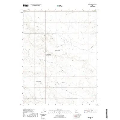
2020 Map of Fruita NW
USGS Topo · Published 2020About this map
Capitol Reef National Park and the arid expanse of the Middle Desert dominate this 2020 landscape, where geological formations are identified with descriptive, evocative names. The desert terrain is punctuated by significant landmarks like the Temple of the Sun, Temple of the Moon, and Jailhouse Rock, reflecting the cultural layer of naming within the park's boundaries. A network of unpaved access routes, such as Temples Road and Jail House Rd, provides the primary means of navigating the undulating geography of Hartnet Draw and the Hartnet Valley Rd. Water is a scarce but vital feature, with Campers Spring, Rockwater Spring, and Deep Cr serving as rare hydrological markers in an otherwise parched environment. The boundary of Wayne Co is visible along the northern edge, indicating the intersection of political and natural borders in this remote region.
Find a feature on this map
19 named features on this map. Tap any name to fly to it.
Don’t see what you’re looking for? This feature index may not catch every label — zoom into the map to look around manually.
Map Details
Editions of this 2020 Fruita NW Map
This is the sole edition of this map. No revisions or reprints were ever made.
Other maps of this area

1885 · Fish Lake
USGS Topo · 1:250,000

1896 · Fish Lake
USGS Topo · 1:250,000

1952 · Notom 2 SE
USGS Topo · 1:24,000

1952 · Notom 2 NE
USGS Topo · 1:24,000

1952 · Notom 1 SW
USGS Topo · 1:24,000

1952 · Torrey
USGS Topo · 1:62,500

1953 · Emery 4 SE
USGS Topo · 1:24,000

1954 · Notom 1 NE
USGS Topo · 1:24,000

1954 · Fruita
USGS Topo · 1:62,500
1954 · Notom 1 SE
USGS Topo · 1:24,000