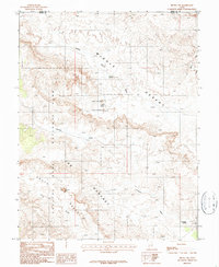
1987 Map of Fruita NW
USGS Topo · Published 1987About this map
Capitol Reef National Park dominates this terrain, where the geology of The Reef meets the expansive basins of the Middle Desert and South Desert. The landscape is defined by massive monolithic formations, most notably the Temple of the Sun and Temple of the Moon located within the Lower Group. This 1980s-era survey captures the area's intricate drainage systems, including the long paths of Middle Desert Wash and Hartnet Draw that cut through the high plateau of Hartnet. Water sources in this arid environment are sparse but critical, marked here by Campers Spring and Rockwater Spring. Further south, the prominent landmark of Jailhouse Rock stands near the winding course of Deep Creek, illustrating the complex erosional history of the Wayne County backcountry.
Find a feature on this map
16 named features on this map. Tap any name to fly to it.
Don’t see what you’re looking for? This feature index may not catch every label — zoom into the map to look around manually.
Map Details
Editions of this 1987 Fruita NW Map
This is the sole edition of this map. No revisions or reprints were ever made.
Other maps of this area

1885 · Fish Lake
USGS Topo · 1:250,000

1896 · Fish Lake
USGS Topo · 1:250,000

1952 · Notom 2 SE
USGS Topo · 1:24,000

1952 · Notom 2 NE
USGS Topo · 1:24,000

1952 · Notom 1 SW
USGS Topo · 1:24,000

1952 · Torrey
USGS Topo · 1:62,500

1953 · Emery 4 SE
USGS Topo · 1:24,000

1954 · Notom 1 NE
USGS Topo · 1:24,000

1954 · Fruita
USGS Topo · 1:62,500
1954 · Notom 1 SE
USGS Topo · 1:24,000