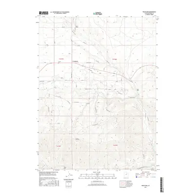
2017 Map of Fruitland
USGS Topo · Published 2017About this map
Fruitland is the primary settlement on this landscape, positioned north of the winding Strawberry River and near the drainage of Red Cr. The town’s history is anchored by the Fruitland Cem, while the surrounding terrain is defined by dramatic elevation changes. High points like Currant Creek Mtn and Cedar Ridge overlook a network of canyons and draws including Timber Draw and Grass Hollow. A complex system of ranching and access roads, such as Lower Ranch Rd and Strawberry Ridge Rd, crisscrosses the high desert environment, indicating the area's ongoing use for land management and recreation. The southern portion of the map follows the course of the Strawberry River toward Hayes Ponds, illustrating how water shaped the early transit routes and settlement patterns in this part of Duchesne County.
Find a feature on this map
39 named features on this map. Tap any name to fly to it.
Don’t see what you’re looking for? This feature index may not catch every label — zoom into the map to look around manually.
Map Details
Editions of this 2017 Fruitland Map
This is the sole edition of this map. No revisions or reprints were ever made.
Other maps of this area

1885 · Uinta
USGS Topo · 1:250,000

1954 · Salt Lake City
USGS Topo · 1:250,000

1958 · Salt Lake City
USGS Topo · 1:250,000

1960 · Salt Lake City
USGS Topo · 1:250,000

1962 · Deep Creek Canyon
USGS Topo · 1:24,000

1962 · Strawberry Pinnacles
USGS Topo · 1:24,000
1962 · Sams Canyon
USGS Topo · 1:24,000

1962 · Fruitland
USGS Topo · 1:24,000

1962 · Tabiona
USGS Topo · 1:24,000

1962 · Raspberry Knoll
USGS Topo · 1:24,000