
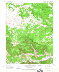
1962 Map of Strawberry Pinnacles
USGS Topo · Published 1963About this map
The Strawberry River carves a deep path through this Duchesne County landscape, creating the striking geological formations known as the Strawberry Pinnacles. These distinctive features stand out near the southern edge of the survey, where the river is fed by a series of drainage systems including Garden Wash, Sams Wash, and Ethier Wash. The topography rises sharply to the north toward Cedar Mountain and the Cedar Rim, reaching elevations over 7,000 feet. The region shows evidence of 20th-century resource exploration with a Mine and Mines located in the eastern portion of the sheet near Hoodoo Canyon and Ethier Wash. A network of jeep trails and a prominent telephone line cut across the high plateaus and through Sink Draw, illustrating the remote utility and access patterns of the early 1960s. The northern reaches are defined by high-desert drainages like Rabbit Gulch and Sams Canyon, which feed into the primary river valley below.
Find a feature on this map
22 named features on this map. Tap any name to fly to it.
Don’t see what you’re looking for? This feature index may not catch every label — zoom into the map to look around manually.
Map Details
Editions of this 1962 Strawberry Pinnacles Map
2 editions found
Other maps of this area

1885 · Uinta
USGS Topo · 1:250,000

1954 · Salt Lake City
USGS Topo · 1:250,000

1958 · Salt Lake City
USGS Topo · 1:250,000

1960 · Salt Lake City
USGS Topo · 1:250,000
1962 · Buck Knoll
USGS Topo · 1:24,000
1962 · Sams Canyon
USGS Topo · 1:24,000

1962 · Blacktail Mtn
USGS Topo · 1:24,000

1962 · Fruitland
USGS Topo · 1:24,000

1962 · Tabiona
USGS Topo · 1:24,000

1962 · Rabbit Gulch
USGS Topo · 1:24,000