
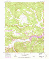
1962 Map of Rabbit Gulch
USGS Topo · Published 1964About this map
The Strawberry River flows through the southern half of this landscape, carving a deep path through the canyonlands of Duchesne County. Mapped in the early 1960s, the area reflects a remote and utilitarian character, dominated by a network of primitive transportation routes labeled as Jeep Trail and a prominent Telephone line crossing the northern heights. Above the river, high features like Blacktail Ridge overlook a complex system of drainages, including Rabbit Gulch and Sink Draw. The early industrial footprint of the region is evidenced by an Oil Well located near the southern boundary, while localized water sources like Pumphouse Spring and Lower Lake suggest the necessary infrastructure for maintaining life and livestock in this arid environment. The map details numerous named topographic features, from Skitzy Canyon to Saleratus Wash, revealing the specific local terminology used by residents and land managers of the era.
Find a feature on this map
16 named features on this map. Tap any name to fly to it.
Don’t see what you’re looking for? This feature index may not catch every label — zoom into the map to look around manually.
Map Details
Editions of this 1962 Rabbit Gulch Map
2 editions found
Other maps of this area

1885 · Uinta
USGS Topo · 1:250,000

1939 · Duchesne
USGS Topo · 1:125,000

1954 · Salt Lake City
USGS Topo · 1:250,000

1958 · Salt Lake City
USGS Topo · 1:250,000

1960 · Salt Lake City
USGS Topo · 1:250,000

1962 · Strawberry Pinnacles
USGS Topo · 1:24,000
1962 · Buck Knoll
USGS Topo · 1:24,000
1962 · Sams Canyon
USGS Topo · 1:24,000

1962 · Blacktail Mtn
USGS Topo · 1:24,000

1962 · Tabiona
USGS Topo · 1:24,000