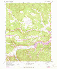
1962 Map of Rabbit Gulch
USGS Topo · Published 1981About this map
The Strawberry River meanders through a deeply incised landscape of Duchesne County, defining the drainage patterns of this high-plateau region. High ground is marked by Blacktail Ridge to the northwest, giving way to a network of dramatic erosion features including Rabbit Gulch, Sink Draw, and Skitzy Canyon. The map records a transition in land use and infrastructure between the original 1958 photogrammetry and 1978 revisions, showing a landscape primarily accessed by Jeep Trails and remote telephone lines.
Find a feature on this map
22 named features on this map. Tap any name to fly to it.
Don’t see what you’re looking for? This feature index may not catch every label — zoom into the map to look around manually.
Map Details
Editions of this 1962 Rabbit Gulch Map
2 editions found

Other maps of this area

1885 · Uinta
USGS Topo · 1:250,000

1939 · Duchesne
USGS Topo · 1:125,000

1954 · Salt Lake City
USGS Topo · 1:250,000

1958 · Salt Lake City
USGS Topo · 1:250,000

1960 · Salt Lake City
USGS Topo · 1:250,000

1962 · Strawberry Pinnacles
USGS Topo · 1:24,000
1962 · Buck Knoll
USGS Topo · 1:24,000
1962 · Sams Canyon
USGS Topo · 1:24,000

1962 · Blacktail Mtn
USGS Topo · 1:24,000

1962 · Tabiona
USGS Topo · 1:24,000