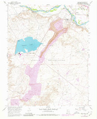
1966 Map of Fruitland
USGS Topo · Published 1980About this map
The Navajo Indian Reservation south of the San Juan River underwent significant industrial transformation during the mid-20th century, as documented in this survey. The landscape is dominated by the sprawling Navajo Mine, a massive open-pit operation feeding the nearby Four Corners Powerplant. This industrial complex is supported by substantial infrastructure, including a series of large Stacks, a Substa, and a dedicated Landing Strip situated near the shores of Morgan Lake.
Find a feature on this map
24 named features on this map. Tap any name to fly to it.
Don’t see what you’re looking for? This feature index may not catch every label — zoom into the map to look around manually.
Map Details
Editions of this 1966 Fruitland Map
Other maps of this area

1889 · Chaco
USGS Topo · 1:250,000

1892 · Chaco
USGS Topo · 1:250,000

1927 · Sulphur Spring
USGS Topo · 1:96,000

1928 · Kirtland
USGS Topo · 1:125,000

1932 · Kirtland
USGS Topo · 1:125,000

1934 · Chimney Rock
USGS Topo · 1:62,500

1936 · Chimney Rock
USGS Topo · 1:62,500

1954 · Shiprock
USGS Topo · 1:250,000

1958 · Shiprock
USGS Topo · 1:250,000

1959 · Shiprock
USGS Topo · 1:250,000