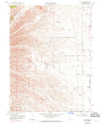
1952 Map of Fruto NE
USGS Topo · Published 1971About this map
Orland Buttes dominate the northern landscape of this Glenn County quadrangle, where the terrain shifts from the elevations of Stone Valley to the western edge of the Sacramento Valley. This map reflects a ranching and agricultural landscape defined by seasonal water management, illustrated by numerous Windmills and a network of drainage systems including North Fork Walker Creek and South Fork Walker Creek. Human presence is anchored by landmarks such as the Michael Ranch and the site of the Cherokee Sch (Abandoned), pointing to a rural community structure that was already evolving by the mid-20th century. The intricate web of a Jeep Trail and various private roads suggests the necessity of off-road access in this foothills environment, connecting various stock tanks and isolated reservoirs along Wilson Creek and French Creek.
Find a feature on this map
20 named features on this map. Tap any name to fly to it.
Don’t see what you’re looking for? This feature index may not catch every label — zoom into the map to look around manually.
Map Details
Editions of this 1952 Fruto NE Map
3 editions found
Other maps of this area

1904 · Vina
USGS Topo · 1:62,500

1904 · Walker Creek
USGS Topo · 1:31,680

1906 · Willows
USGS Topo · 1:62,500

1914 · Kirkwood
USGS Topo · 1:31,680

1914 · Orland
USGS Topo · 1:31,680

1917 · Kurand
USGS Topo · 1:31,680

1917 · Lyman
USGS Topo · 1:31,680

1919 · Fruto
USGS Topo · 1:62,500

1944 · Fruto
USGS Topo · 1:62,500

1944 · Flournoy
USGS Topo · 1:62,500