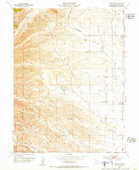
1952 Map of Fruto NE
USGS Topo · Published 1952About this map
Orland Buttes dominate the northern landscape of this 1952 topographic study of western Glenn County, marking a transition between the Sacramento Valley and the Coast Range foothills. This era of land management is defined by numerous scattered Windmills, water tanks, and reservoirs, illustrating the vital infrastructure required for ranching in this dry drainage basin. The map documents the Michael Ranch, located near a Levee on a central waterway, providing a specific record of agricultural property boundaries and water rights during the mid-century. Cultural markers such as the Cherokee Sch (Abandoned) offer a window into the shifting demographics of rural California, while the complex network of seasonal drainages, including North Fork Walker Creek and Stone French Valley Creek, shows the intricate natural watershed before more modern developments. The survey, conducted under State Engineer A. D. Edmonston, provides an essential record of local geography as it stood during the governorship of Earl Warren.
Find a feature on this map
16 named features on this map. Tap any name to fly to it.
Don’t see what you’re looking for? This feature index may not catch every label — zoom into the map to look around manually.
Map Details
Editions of this 1952 Fruto NE Map
3 editions found
Other maps of this area

1904 · Vina
USGS Topo · 1:62,500

1904 · Walker Creek
USGS Topo · 1:31,680

1906 · Willows
USGS Topo · 1:62,500

1914 · Kirkwood
USGS Topo · 1:31,680

1914 · Orland
USGS Topo · 1:31,680

1917 · Kurand
USGS Topo · 1:31,680

1917 · Lyman
USGS Topo · 1:31,680

1919 · Fruto
USGS Topo · 1:62,500

1944 · Fruto
USGS Topo · 1:62,500

1944 · Flournoy
USGS Topo · 1:62,500