
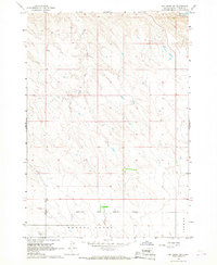
1966 Map of Ft. George Butte SE
USGS Topo · Published 1967About this map
Lower Brule Indian Reservation land dominates this 1966 topographic survey of Lyman County, South Dakota, revealing a sparsely settled prairie landscape characterized by its historical administrative boundaries. The terrain is marked by the Apple Gate upland and the winding path of Grouse Creek, while the intricate web of human history is visible through the Old Indian Treaty Boundary and the presence of the Annin district. This era of mapping captures the region before significant modern development, emphasizing the importance of local infrastructure such as the Brule Sch and unique landmarks like the Dipping Tank. The settlement pattern implies a community tightly linked to the land and the formal divisions of the reservation, providing a precise record of rural life and land management during the mid-1960s.
Find a feature on this map
8 named features on this map. Tap any name to fly to it.
Don’t see what you’re looking for? This feature index may not catch every label — zoom into the map to look around manually.
Map Details
Editions of this 1966 Ft. George Butte SE Map
This is the sole edition of this map. No revisions or reprints were ever made.
Other maps of this area

1953 · Huron
USGS Topo · 1:250,000

1954 · Pierre
USGS Topo · 1:250,000

1954 · Huron
USGS Topo · 1:250,000

1955 · Martin
USGS Topo · 1:250,000

1955 · Mitchell
USGS Topo · 1:250,000

1958 · Pierre
USGS Topo · 1:250,000

1958 · Martin
USGS Topo · 1:250,000

1959 · Mitchell
USGS Topo · 1:250,000

1966 · Joe Creek NW
USGS Topo · 1:24,000
1966 · Joe Creek SW
USGS Topo · 1:24,000