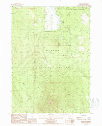
1988 Map of Fuego Mountain
USGS Topo · Published 1988About this map
Fuego Mountain dominates the southern landscape of this Oregon territory, standing as a prominent landmark within the Winema National Forest. The 1980s terrain is defined by high-altitude features like Taylor Butte and the winding course of the Williamson River in the northeast. This map reveals a land managed for both conservation and resource use, indicated by the presence of a Cinder Pit and various livestock-related features such as The Bull Pasture and several scattered water sources including Willow Pond and Coyote Spring. A notable human imprint on this natural landscape is the Private Treaty Boundary cutting across the northern sections, marking a significant legal and historical division of the land. The network of unimproved roads and trails through Wildhorse Meadow reflects the era's focus on forest management and backcountry access.
Find a feature on this map
15 named features on this map. Tap any name to fly to it.
Don’t see what you’re looking for? This feature index may not catch every label — zoom into the map to look around manually.
Map Details
Editions of this 1988 Fuego Mountain Map
This is the sole edition of this map. No revisions or reprints were ever made.
Other maps of this area

1889 · Klamath
USGS Topo · 1:250,000

1894 · Klamath
USGS Topo · 1:250,000

1955 · Klamath Falls
USGS Topo · 1:250,000

1956 · Calimus Butte
USGS Topo · 1:62,500

1957 · Klamath Marsh
USGS Topo · 1:62,500

1958 · Klamath Falls
USGS Topo · 1:250,000

1960 · Fuego Mountain
USGS Topo · 1:62,500

1960 · Yamsay Mountain
USGS Topo · 1:62,500

1980 · Williamson River
USGS Topo · 1:100,000
1988 · Calimus Butte
USGS Topo · 1:24,000