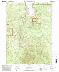
1998 Map of Fuego Mountain
USGS Topo · Published 2000About this map
Winema National Forest dominates this high-altitude terrain in Klamath County, where the volcanic profile of Fuego Mountain rises above a landscape defined by significant hydrologic features. The map illustrates a network of essential water sources that sustained both local wildlife and forestry operations in the late 20th century, notably the Head of the River Springs and several smaller outlets like Coyote Spring and Wildhorse Spring. The topography transitions from the open stretches of The Bull Pasture and Wildhorse Meadow to the steep relief of Taylor Butte. This 1990s revision reflects the Forest Service's detailed management of the area, showing the precise intersection of natural drainages such as Deer Draw with the established boundaries of the national forest system.
Find a feature on this map
13 named features on this map. Tap any name to fly to it.
Don’t see what you’re looking for? This feature index may not catch every label — zoom into the map to look around manually.
Map Details
Editions of this 1998 Fuego Mountain Map
This is the sole edition of this map. No revisions or reprints were ever made.
Other maps of this area

1889 · Klamath
USGS Topo · 1:250,000

1894 · Klamath
USGS Topo · 1:250,000

1955 · Klamath Falls
USGS Topo · 1:250,000

1956 · Calimus Butte
USGS Topo · 1:62,500

1957 · Klamath Marsh
USGS Topo · 1:62,500

1958 · Klamath Falls
USGS Topo · 1:250,000

1960 · Fuego Mountain
USGS Topo · 1:62,500

1960 · Yamsay Mountain
USGS Topo · 1:62,500

1980 · Williamson River
USGS Topo · 1:100,000
1988 · Calimus Butte
USGS Topo · 1:24,000