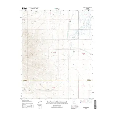
2016 Map of Fulcher Gulch
USGS Topo · Published 2016About this map
The boundary between Rio Grande and Conejos counties bisects this landscape, which is defined by an intricate network of irrigation systems and drainages. The eastern flats are crisscrossed by agricultural infrastructure, including the Monte Vista Canal, Sheridans Ditch, and the aptly named Resettlement Ditch. These waterways support the valley floor before the terrain rises sharply to the west into more complex topography. Moving toward the higher ground, Goat Ranch Gulch and Fulcher Gulch carve through the foothills, while Goat Ranch Spring provides a permanent water source in the uplands. Significant geographic landmarks like The Canyon and seasonal flows such as Cat Cr characterize the southwestern portion of the map. The road network, including the straight north-south line of Gunbarrel Rd and several Forest Service routes like FDR 250, provides access between the managed irrigation lands and the rising mountain slopes.
Find a feature on this map
35 named features on this map. Tap any name to fly to it.
Don’t see what you’re looking for? This feature index may not catch every label — zoom into the map to look around manually.
Map Details
Editions of this 2016 Fulcher Gulch Map
This is the sole edition of this map. No revisions or reprints were ever made.
Other maps of this area

1915 · Del Norte
USGS Topo · 1:125,000

1917 · Del Norte
USGS Topo · 1:125,000

1922 · Conejos
USGS Topo · 1:125,000

1945 · Durango
USGS Topo · 1:250,000

1953 · Durango
USGS Topo · 1:250,000

1954 · Durango
USGS Topo · 1:250,000

1961 · Durango
USGS Topo · 1:250,000

1963 · Durango
USGS Topo · 1:250,000

1964 · Monte Vista
USGS Topo · 1:24,000

1966 · Durango
USGS Topo · 1:250,000