1967 Map of Fulks Run
USGS Topo · Published 1969About this map
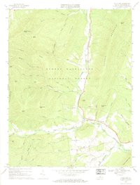
The North Fork Shenandoah River carves a narrow valley through the heart of the George Washington National Forest in this 1967 survey. The settlement of Fulks Run serves as a local hub near several river fords and the Roadside Park. This era of the landscape is defined by small, dispersed rural communities like Yankeetown and Genoa, each marked by their local congregations such as Riverside Ch and Mountain Grove Ch.
Find a feature on this map
58 named features on this map. Tap any name to fly to it.
Don’t see what you’re looking for? This feature index may not catch every label — zoom into the map to look around manually.
Map Details
Editions of this 1967 Fulks Run Map
This is the sole edition of this map. No revisions or reprints were ever made.
Other maps of this area

1892 · Franklin
USGS Topo · 1:125,000

1892 · Woodstock
USGS Topo · 1:125,000

1896 · Franklin
USGS Topo · 1:125,000

1920 · Petersburg
USGS Topo · 1:48,000

1921 · Orkney Springs
USGS Topo · 1:48,000

1921 · Petersburg
USGS Topo · 1:48,000

1922 · Fort Seybert
USGS Topo · 1:48,000

1922 · Petersburg
USGS Topo · 1:62,500

1923 · Orkney Springs
USGS Topo · 1:62,500

1924 · Fort Seybert
USGS Topo · 1:62,500