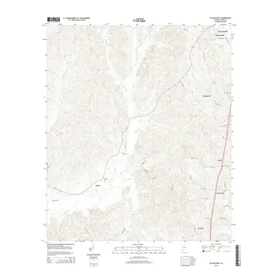
2014 Map of Fulton West
USGS Topo · Published 2014About this map
Thomasville and the surrounding timberlands of Clarke County define this corner of Southwest Alabama. The landscape is carved by the extensive drainage of Salitpa Cr, which flows southward through the heart of the area toward Chilton. This 2014 survey documents a network of local roads and family-named landmarks that connect smaller communities like Springfield, Greenwood, and Peacock. Significant water features such as Solomons Lake and Scotch Club Lake are nestled among the drainages of Wells Cr and Bassett Cr. Genealogists and local historians can find points of interest in rural burial sites like Smiths Cem and Kelley Cem, as well as several old road alignments including Dummy Line Rd and Old Almeda Rd. The settlement pattern reflects the area's rural character, centered around the commerce and rail access of Fulton and the northern hub of Thomasville.
Find a feature on this map
42 named features on this map. Tap any name to fly to it.
Don’t see what you’re looking for? This feature index may not catch every label — zoom into the map to look around manually.
Map Details
Editions of this 2014 Fulton West Map
This is the sole edition of this map. No revisions or reprints were ever made.
Other maps of this area

1953 · Andalusia
USGS Topo · 1:250,000

1957 · Andalusia
USGS Topo · 1:250,000

1972 · Whatley
USGS Topo · 1:24,000

1973 · Fulton East
USGS Topo · 1:24,000

1973 · Thomasville
USGS Topo · 1:24,000

1978 · McEntyre
USGS Topo · 1:24,000
1978 · Bashi
USGS Topo · 1:24,000

1978 · Winn
USGS Topo · 1:24,000
1978 · Morvin
USGS Topo · 1:24,000
1978 · Grove Hill
USGS Topo · 1:24,000