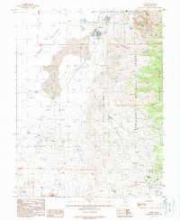
1988 Map of Gabbs
USGS Topo · Published 1988About this map
The town of Gabbs sits at the base of the Paradise Range in this late-1980s survey, serving as a hub for the extensive mining operations that define this section of the Toiyabe National Forest. The map documents a landscape heavily shaped by mineral extraction, from the large Open Pit Mine and Sierra Mine in the north to the Paradise Peak Mine and Davis Mine further south. These workings are connected by a network of unimproved roads and 4WD tracks that spider through Cottonwood Canyon and Sheep Canyon. To the west, the arid floor of Gabbs Valley is marked by Sand Dunes and the essential water source at Kellys Wells. Of particular interest to historians is the Brucite (Site) east of town, indicating a former settlement or facility associated with the area's industrial past, while local infrastructure like the Athletic Field and Landing Strip show the footprint of the resident community.
Find a feature on this map
52 named features on this map. Tap any name to fly to it.
Don’t see what you’re looking for? This feature index may not catch every label — zoom into the map to look around manually.
Map Details
Editions of this 1988 Gabbs Map
This is the sole edition of this map. No revisions or reprints were ever made.
Other maps of this area

1907 · Tonopah
USGS Topo · 1:250,000

1908 · Tonopah
USGS Topo · 1:250,000

1909 · Hawthorne
USGS Topo · 1:250,000

1911 · Hawthorne
USGS Topo · 1:250,000

1915 · Hawthorne
USGS Topo · 1:250,000

1948 · Paradise Peak
USGS Topo · 1:62,500

1948 · Walker Lake
USGS Topo · 1:250,000

1950 · Paradise Peak
USGS Topo · 1:62,500

1956 · Tonopah
USGS Topo · 1:250,000

1957 · Walker Lake
USGS Topo · 1:250,000