
1981 Map of Gacho Hill NW
USGS Topo · Published 1981About this map
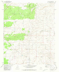
Vicente Ranch and Del Curto Ranch anchor this landscape in western Guadalupe County during the mid-1970s. The terrain is defined by the sweeping course of Marino Draw, which cuts through the high desert topography toward the prominent rise of Gacho Hill. This map captures a moment of sparse high-plains settlement where survival depended on localized infrastructure, indicated by numerous scattered Well and Tank sites across the ranch lands. A prominent Pipeline traverses the southern sections, marking a modern industrial intrusion into the traditional grazing territory. The cartography reflects the transition from classic ranching life to energy transportation, while preserving the family-named landholdings essential for genealogical research in this part of New Mexico.
Find a feature on this map
8 named features on this map. Tap any name to fly to it.
Don’t see what you’re looking for? This feature index may not catch every label — zoom into the map to look around manually.
Map Details
Editions of this 1981 Gacho Hill NW Map
This is the sole edition of this map. No revisions or reprints were ever made.
Other maps of this area

1954 · Fort Sumner
USGS Topo · 1:250,000

1958 · Fort Sumner
USGS Topo · 1:250,000

1978 · Vaughn
USGS Topo · 1:24,000

1978 · Tejon
USGS Topo · 1:24,000

1978 · Long Draw
USGS Topo · 1:24,000

1980 · Corona
USGS Topo · 1:100,000

1981 · Gacho Hill SW
USGS Topo · 1:24,000

1981 · Camaleon Draw East
USGS Topo · 1:24,000

1981 · Gacho Hill SE
USGS Topo · 1:24,000
1981 · Duran NE
USGS Topo · 1:24,000