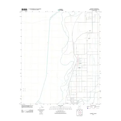
2011 Map of Gadsden
USGS Topo · Published 2011About this map
Gadsden and the surrounding agricultural tracts of the Yuma Valley are the focus of this 2011 survey of the Arizona-Baja California Norte borderlands. The landscape is defined by a dense grid of irrigation infrastructure, including the Southwest Lateral, which supports the region's intensive farming operations. A small residential cluster centers on the Gadsden Post Office, while McDaniel Field and the Somerton Siding railroad point indicate the area's role as a logistical hub for moving produce. The map also includes a label for the Gadsden Purchase, referencing the historical 1854 land acquisition that shaped the current international boundary. This modern topographic view shows how the desert environment has been transformed into a productive horticultural zone through an intricate network of canals and numbered county roads.
Find a feature on this map
32 named features on this map. Tap any name to fly to it.
Don’t see what you’re looking for? This feature index may not catch every label — zoom into the map to look around manually.
Map Details
Editions of this 2011 Gadsden Map
This is the sole edition of this map. No revisions or reprints were ever made.
Other maps of this area

1903 · Yuma
USGS Topo · 1:125,000

1905 · Yuma
USGS Topo · 1:125,000

1940 · Yuma
USGS Topo · 1:62,500

1942 · Yuma
USGS Topo · 1:250,000

1945 · Yuma
USGS Topo · 1:62,500

1952 · Yuma West
USGS Topo · 1:24,000

1953 · Grays Well
USGS Topo · 1:24,000
1953 · Grays Well NE
USGS Topo · 1:24,000

1954 · El Centro
USGS Topo · 1:250,000

1955 · El Centro
USGS Topo · 1:250,000