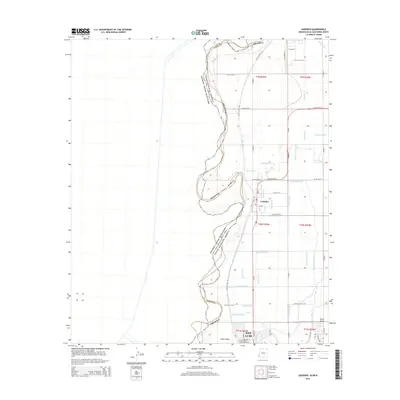
2014 Map of Gadsden
USGS Topo · Published 2014About this map
Yuma County agriculture and international borders define this 2014 survey of the desert southwest. The settlement of Gadsden sits at the heart of an intricate irrigation network in the Yuma Valley, where the landscape is etched with a systematic grid of water-management features. Numerous named waterways like the Adams Lateral, Schutz Lateral, and Barkley Lateral support the local farming economy. To the south, the city of San Luis serves as a significant hub on the border between the United States and Mexico. The western edge of the map follows the winding path of the Arizona state line as it traces the former course of the Colorado River, creating a complex boundary that separates the lush valley from the more arid Yuma Desert to the east.
Find a feature on this map
46 named features on this map. Tap any name to fly to it.
Don’t see what you’re looking for? This feature index may not catch every label — zoom into the map to look around manually.
Map Details
Editions of this 2014 Gadsden Map
This is the sole edition of this map. No revisions or reprints were ever made.
Other maps of this area

1903 · Yuma
USGS Topo · 1:125,000

1905 · Yuma
USGS Topo · 1:125,000

1940 · Yuma
USGS Topo · 1:62,500

1942 · Yuma
USGS Topo · 1:250,000

1945 · Yuma
USGS Topo · 1:62,500

1952 · Yuma West
USGS Topo · 1:24,000

1953 · Grays Well
USGS Topo · 1:24,000
1953 · Grays Well NE
USGS Topo · 1:24,000

1954 · El Centro
USGS Topo · 1:250,000

1955 · El Centro
USGS Topo · 1:250,000